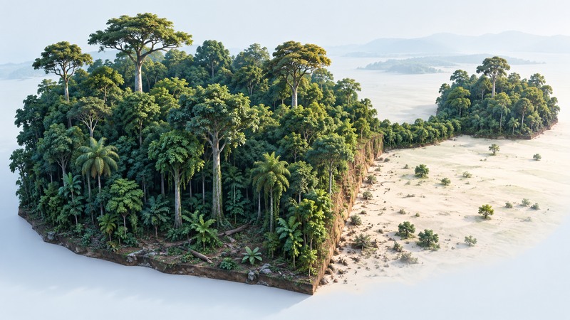
A rainforest picture can reveal canopy structure, a clearing or a forest edge. Its value grows when the caption identifies the place, date, viewpoint and type of image. A photograph records a scene; an illustration can organize relationships for learning.
Use this guide to describe what is visible, identify the information still needed and avoid turning an attractive picture into an unsupported ecological claim. For species, begin with a named region: Amazonia, the Congo Basin and Southeast Asian forests have different communities.
Read from the crowns to the forest floor
Smithsonian’s rainforest layers explanation describes emergent trees, canopy, understory and forest floor. These are useful viewing categories, with light and wind changing through the vegetation. Individual forests have gaps, varied crown heights and local differences.
On a narrow screen, scroll the table sideways. Keyboard users can focus it and use the arrow keys.
| Layer or feature | Visible clue | Useful question |
|---|---|---|
| Emergent crowns | Individual crowns rise above surrounding foliage. | Is there enough scale information to estimate height? |
| Canopy | A dense surface of overlapping crowns. | Are openings natural gaps, roads or clearing? |
| Understory | Smaller trees and vegetation beneath taller crowns. | Does the viewpoint actually show this layer? |
| Forest floor | Litter, roots, fallen wood and low plants. | How do season and moisture affect the scene? |
| Edge | Forest meets a contrasting open area. | What is the adjoining land use and age of the edge? |
An aerial view can show patch shape while hiding much of the understory. A ground-level image can reveal trunks and seedlings while giving little information about total canopy continuity. Pair viewpoints when the question spans both scales.
Notice the boundary and the surrounding land
A long-term Amazonian research project provides a useful historical example. The 2002 Biological Dynamics of Forest Fragments Project synthesis describes strong edge influences and the importance of surrounding vegetation for fragment dynamics and connectivity.
Use that evidence to ask about edge conditions, fragment history and the species involved. A distance reported for a particular response in that experiment is specific to its context. Different organisms, climates, adjacent land uses and time since clearing can produce different responses.
Look beyond the green patch to the intervening landscape. Regrowth, pasture, roads and water can affect movement differently. A visible strip of trees suggests a possible connection; evidence that a particular species uses it requires observation or research.
Write a caption that separates observation and inference
Begin with source, location, date and viewpoint. Describe visible features before interpreting them: “A road separates two areas of closed canopy” is directly observable; “the road prevents all animal movement” requires additional evidence.
Use an expert identification for species claims that matter. A distant crown or indistinct animal rarely supports a precise species label. A lush scene also needs independent evidence for claims about forest age, carbon storage, biodiversity or protection status.
For generated or reconstructed images, label the image type and describe the teaching purpose. The illustration above combines structural features for explanation and represents no surveyed plot. Keep photo rights and source attribution with any image you plan to share.
Build a repeatable observation
For a permitted field visit, use established access routes and record a consistent viewpoint, date, weather and visible features. Avoid disturbing wildlife or vegetation to improve a photograph. If comparing repeat images, match the view and season as closely as possible and record differences.
Finish with three lines: what is visible, what you infer, and what evidence would test that inference. The cloud forest guide adds a related explanation of moisture, elevation and local context.
Rainforest image observation sheet
Rainforest image observation sheet — plain-text download. Save a copy and fill it in with your own information. It includes instructions, example assumptions and source references.