BAE Systems has introduced a day/night, all-weather capability designed to enable pilots to navigate and land in degraded visual environments. The capability combines radar, infrared sensors, and low-light-level TV to enable pilot visibility in dust-outs, smoke, fog, haze, rain, snow, and complete darkness.
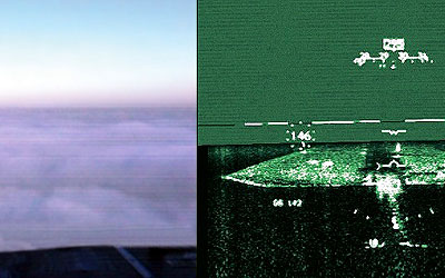
The system consists of BAE Systems Radar-Enhanced Vision System, a multimode, millimeter-wave radar, integrated with forward-looking infrared, low-light-level television, and proprietary sensor fusion technology to enable operation in zero-ceiling/zero-visibility (0/0) environments. The fused image is displayed either on a head-up or helmet-mounted display.
"One of the most dangerous challenges military aviators face is poor visibility, a fact that has been underscored by recent operations in unprepared environments in Iraq and Afghanistan," said Dutch Neilson, leader of the BAE Systems Platform Solutions team that developed the technology. "Our system provides the best and most affordable solution to the hazards caused by dust generated during landing and take-off, smoke in battlefield areas, and adverse weather."
The millimeter-wave Radar-Enhanced Vision System serves as the primary sensor, exploiting the characteristics of dust, suspended water, and atmospheric transmission to generate an image that, when fused with information provided by the infrared and low-light TV systems, provides a robust, redundant capability. Data from all three sensors are combined to produce the best available image at any moment in time.
BAE Systems also can combine the sensor suite with its own flight control and active stick technology to provide pilots tactile cues throughout the flight envelope. In addition, the system can be integrated with the company's TERPROM digital terrain system, with uses stored digital elevation data to provide a sensor-independent model of terrain and obstacles to apprise pilots of their proximity to terrain or other obstacles.
BAE Systems is offering the technology for both fixed- and rotary-wing aircraft and is demonstrating the capability this week at the Army Aviation Association of America's annual convention in Nashville, Tenn.
To date, elements of the system have been demonstrated on a U.S. Air Force C-130 transport, where it was tested to near 0/0 conditions. Currently, it's being installed on a C-17 transport as part of an Air Force dual-use initiative, through Boeing Phantom Works, and later this year will be demonstrated on a CH-47 helicopter as part of a U.S. Army initiative to address white-out/dust-out operational issues experienced in Afghanistan and Iraq. Additionally, BAE Systems is beginning a research program with the Air Force Research Lab at Wright-Patterson Air Force Base to evaluate various millimeter-wave radar modes that have application to the landing requirements as well as other platform needs, such as unmanned aerial vehicles.
BAE Systems Platform Solutions Sector provides a wide range of products and capabilities that include fly-by-wire flight controls, digital autopilots and flight directors, military ground support equipment, full-authority digital engine controls, inertial sensors and navigation guidance systems, displays, integrated avionics, power management systems, unmanned aerial vehicle systems, low-visibility precision landing systems, air traffic management systems, launch-vehicle controls, and hybrid electric vehicle drive systems.