Transportation asset tracking has advanced far beyond the periodic satellite position reports available when this article was first published. A modern platform can follow a trailer, railcar, chassis, container, vessel, pallet or high-value package across several modes of transport. It can also report temperature, humidity, shock, tilt, light exposure, door openings, tire pressure, fuel level and whether a load is present.
The most capable systems do not depend on one radio or one map. They combine outdoor and indoor location methods, select among terrestrial and satellite connections, conserve power when an asset is stationary, and convert raw signals into useful events. The result is a continuous operational record: where the asset has been, who handled it, whether its cargo remained within specification, when it should arrive and which exception requires attention.
From dots on a map to decision-ready visibility
A location coordinate is only the beginning. Fleet operators need to know whether a trailer is loaded, detained at a customer, parked in the wrong yard, moving without authorization or likely to miss an appointment. Rail operators may need wagon location, impact history and handoff status. Marine and intermodal users need container milestones across terminals, ships, trains and trucks. Cold-chain managers need proof that temperature and humidity remained within limits throughout the journey.
Modern platforms therefore organize telemetry into events and exceptions. A geofence can record arrival and departure without waiting for a driver to check in. A light sensor can identify an unexpected door opening. An accelerometer can distinguish ordinary vibration from a severe impact. Temperature readings can trigger an alert only when duration and product-specific limits create a genuine risk, reducing alarm fatigue.
Cloud analytics then combine those device events with dispatch plans, traffic, weather, port calls, vessel schedules, terminal activity and historical travel times. Estimated arrival times are continually recalculated, while exception-management tools direct attention toward loads that need intervention instead of requiring personnel to watch every asset.
The connectivity toolbox
No single network provides the best combination of coverage, cost, bandwidth and battery life everywhere. Current trackers increasingly use multiple radios and switch among them according to availability and policy.
| Technology | Best suited to | Principal advantage | Important limitation |
|---|---|---|---|
| 4G LTE and 5G | Powered trucks, gateways, video and frequent telemetry | Broad terrestrial coverage and enough bandwidth for rich data | Higher power consumption and coverage gaps in remote areas |
| LTE-M | Mobile battery-powered trackers and moderate-rate sensor data | Mobility support, relatively low power use and established cellular infrastructure | Availability and roaming arrangements vary by country and operator |
| NB-IoT | Small, infrequent messages from stationary or slowly moving assets | Deep coverage and long battery life | Not every deployment is optimized for continuous cross-border mobility |
| Satellite IoT | Ocean, desert, rural and other off-network operations | Coverage beyond terrestrial cellular networks | Device orientation, antenna view, message cost and latency still matter |
| LoRaWAN | Yards, ports, campuses, depots and regional low-power networks | Long range with very low device power requirements | Requires suitable public or private gateway coverage |
| Bluetooth Low Energy | Pallets, tools, packages and indoor zones | Low-cost tags and compatibility with phones and fixed gateways | Usually depends on a nearby gateway or participating device |
| UWB and Bluetooth positioning | Precise indoor location, secure ranging and automated yards | Much finer location than conventional proximity beacons | Infrastructure and tag cost can limit large-area deployment |
| RFID and NFC | Identity and checkpoint events | Inexpensive tags, fast reading and little or no tag battery use | Generally records presence at a reader rather than continuous location |
Satellite tracking is becoming part of the cellular ecosystem
Satellite remains essential for ships, remote rail corridors, long-haul trailers and equipment that routinely leaves terrestrial coverage. Traditional satellite terminals use specialized networks and hardware. That model remains valuable, particularly where dependable global service matters more than device cost or message volume.
A newer development is the integration of satellites into mobile standards. The 3rd Generation Partnership Project made non-terrestrial networks, or NTN, a formal part of 5G specifications in Release 17. Its work includes satellite access for 5G as well as NB-IoT and enhanced machine-type communication. The 3GPP NTN framework is intended to support service continuity and more standardized interaction between terrestrial and satellite networks.
For tracking, the long-term significance is less about turning every sensor into a satellite phone than about simplifying coverage. Standards-based chipsets and modules can eventually let a device use a familiar cellular-oriented architecture when terrestrial towers disappear. Early implementations still differ in supported spectrum, satellite constellation, antenna requirements, roaming, message size and geographic availability, so buyers should verify actual coverage and commercial readiness rather than relying on a generic “satellite enabled” label.
Positioning outdoors, indoors and between modes
Most outdoor trackers now use multi-constellation global navigation satellite systems rather than GPS alone. Receiving GPS, Galileo, GLONASS, BeiDou or regional signals can improve availability and time to first fix, although containers, buildings and dense urban areas still obstruct satellite views. Assisted GNSS can reduce acquisition time by supplying orbital data over a network, while motion-aware firmware avoids wasting power on fixes when an asset has not moved.
Indoors, trackers may scan Wi-Fi access points or Bluetooth beacons and send identifiers to a location service. Bluetooth Direction Finding can estimate signal angle, while Bluetooth Channel Sounding adds more accurate and secure distance measurement for compatible devices. UWB measures signal timing for fine-ranging applications such as locating a specific trailer bay, container stack position or piece of ground equipment.
Good systems treat these methods as complementary. GNSS may locate a trailer on the highway, cellular or Wi-Fi data may place it near a warehouse, and Bluetooth or UWB may identify its exact indoor or yard zone. Sensor fusion combines radio observations with accelerometer, gyroscope and vehicle data to smooth gaps and reject implausible jumps.
Smarter, lower-power devices
Unpowered assets impose a strict energy budget. A tracker mounted on a container or trailer may need to operate for years without service, through heat, cold, vibration, salt spray and pressure washing. Battery life depends on much more than nominal battery capacity: position-fix frequency, weak-signal searching, radio transmissions, sensor sampling, temperature and firmware behavior all affect the result.
Edge processing now allows the device to transmit meaning instead of every reading. It can remain in a deep-sleep state until movement begins, summarize stable temperature readings, recognize a trip, and immediately report only an exception. Store-and-forward memory preserves events when no network is available. Remote configuration and secure firmware updates let operators adjust reporting intervals or repair software without touching thousands of deployed units.
Energy harvesting from a tractor connection, railcar vibration or a small solar panel can extend service life, but it does not eliminate the need for disciplined power management. Replaceable primary batteries remain practical for many low-message-rate devices; rechargeable designs make more sense when a predictable energy source is available.
Condition monitoring and smart cargo
Tracking increasingly follows the cargo as well as the conveyance. Small reusable loggers can travel inside a pallet or carton and communicate with a vehicle gateway. Smart-container devices monitor doors, motion and environmental conditions. Reefer integrations add return-air and supply-air temperature, set point, power status and machinery alarms. Electronic seals can report tampering or a door event rather than merely showing physical evidence at destination.
These measurements support cold-chain compliance, theft investigation, insurance claims, maintenance and product-quality decisions. They also require context. A temperature excursion beside a container wall may not represent the temperature at the product core, and a sudden shock may be harmless for one commodity but damaging for another. Sensor placement, calibration, sampling rate and threshold logic must match the actual risk.
Computer vision, telematics and digital twins
Fixed cameras at gates and yards can read license plates, container numbers and chassis markings, creating automated arrival and interchange events. On powered vehicles, telematics gateways combine location with engine data, electronic logging, tire-pressure systems, driver-safety sensors and increasingly video. Machine vision can detect occupied parking positions, damaged equipment or containers placed in the wrong stack.
A digital twin is the software representation that brings these observations together. For an asset, it may contain identity, ownership, current position, trip, cargo, sensor state, maintenance history and predicted arrival. The valuable feature is not a three-dimensional image; it is a consistent operational record that applications can query and update.
Machine-learning models can estimate arrival times, identify route or dwell-time anomalies, predict reefer or vehicle faults and prioritize likely theft events. Their output is only as reliable as the underlying events. Missing handoffs, duplicated identifiers and inconsistent carrier milestones can mislead a sophisticated model, which is why data standards have become as important as tracker hardware.
Interoperability is the next major advance
A shipment often changes custody, vehicle and communications provider several times. Proprietary dashboards are useful within one fleet but cannot alone provide end-to-end visibility. Standard identifiers, event vocabularies and application programming interfaces allow shippers, carriers, terminals and customers to exchange selected data without forcing everyone onto the same platform.
GS1 EPCIS 2.0 provides a common way to describe visibility events, including sensor information: what happened, when, where and in what business context. For container shipping, the Digital Container Shipping Association Track & Trace standard defines interoperable data models and APIs for container whereabouts and operational events. DCSA also publishes IoT and reefer-event specifications for equipment fitted with sensors.
UN/CEFACT's integrated multimodal track-and-trace work addresses identified products, packages and transport equipment across modes. Electronic consignment notes and transport documents complement physical telemetry by connecting the observed journey to commercial and regulatory records.
Security, privacy and trustworthy evidence
Every connected tracker expands the system's attack surface. Devices should use unique credentials, encrypted communications, signed firmware, secure boot where practical and a supported update process. Platforms need role-based access, audit logs, retention rules and controls that prevent one customer from seeing another customer's assets. Installation should resist casual removal without obstructing antennas or creating a safety hazard.
Location data can reveal valuable cargo, customer activity and driver behavior. Organizations should collect only what serves a defined operational purpose, disclose employee monitoring appropriately, limit sharing and set deletion schedules. High-value or regulated uses also need evidence that device clocks, identities, calibrations and event histories have not been altered.
Selecting a modern tracking system
The best device is not necessarily the one with the longest feature list. Selection begins with the decisions the data must support. A returnable pallet may need a low-cost Bluetooth tag and checkpoint visibility. A pharmaceutical shipment may justify calibrated sensors, redundant connectivity and immediate escalation. A trailer fleet may care most about loaded status, yard dwell and years of unattended battery life.
| Question | What to verify |
|---|---|
| Where will the asset travel? | Measured terrestrial and satellite coverage, roaming, indoor performance and regional radio approvals |
| How quickly must an exception be known? | Reporting interval, network latency, retry behavior and store-and-forward capability |
| How long must the device operate? | Battery estimate under the real trip profile, temperature range and weak-signal conditions |
| What condition evidence is required? | Sensor accuracy, calibration, placement, sampling, thresholds and immutable history |
| Can the data leave the vendor's dashboard? | Documented APIs, webhooks, standardized events, export rights and integration costs |
| Can the fleet be maintained securely? | Remote diagnostics, signed updates, credential management, support period and end-of-life plan |
| Will alerts improve an operation? | Named response owner, escalation workflow and measurable reduction in loss, delay or manual effort |
The 2005 GlobalWave system in perspective
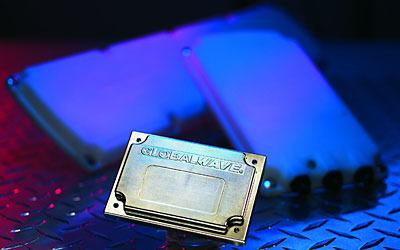
The original subject of this article was TransCore's GlobalWave satellite terminal. At the time, its compact modem, integrated GPS, two-way messaging, sub-minute response and claimed battery life of as much as seven years represented an important improvement for unpowered trailer tracking. A sensor-enabled version could report loaded status, cargo temperature and tire inflation through a web interface.
Its basic design priorities remain recognizable: inconspicuous hardware, rapid installation, extreme-weather durability, long battery life and integration with transportation-management software. What has changed is the surrounding ecosystem. Today's tracker can choose among several networks, locate assets inside buildings, process sensor data at the edge, exchange standardized events through APIs and feed predictive operational models.
The direction of the industry is therefore not simply toward more frequent dots on a map. It is toward resilient, multimodal evidence: a shared account of an asset's identity, location, condition, custody and expected progress. Satellite communication still closes the hardest coverage gaps, but the largest gains now come from combining it intelligently with terrestrial IoT, precise local positioning, trustworthy sensors and interoperable data.