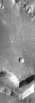
 This THEMIS image shows a sinuous valley network channel with sharp bends cutting across the cratered highlands of the southern hemisphere of Mars. The channel is named Nirgal Vallis, which is from the Babylonian word for "Mars". Nirgal Vallis is a channel with a total length of approximately 500 km. It is approximately 6 km wide in this region. Gullies and alluvial deposits discovered by Mars Global Surveyor are clearly visible on the polar-facing (south) wall and floor of Nirgal Vallis. These gullies appear to emanate from a specific layer in the walls. There is a pronounced sparsity of gullies on the equator-ward facing slopes. The gullies have been proposed to have formed by the subsurface release of water. Patches of dunes are also seen on the channel floor, notably along the edges of the channel floor near the canyon walls. There is still debate within the scientific community as to how valley networks themselves form: surface runoff (rainfall/snowmelt) or headward erosion via groundwater sapping. This image is approximately 22 km wide and 60 km in length; north is toward the top.

NASA's Jet Propulsion Laboratory manages the 2001 Mars Odyssey mission for NASA's Office of Space Science, Washington, D.C. The Thermal Emission Imaging System (THEMIS) was developed by Arizona State University, Tempe, in collaboration with Raytheon Santa Barbara Remote Sensing. The THEMIS investigation is led by Dr. Philip Christensen at Arizona State University. Lockheed Martin Astronautics, Denver, is the prime contractor for the Odyssey project, and developed and built the orbiter. Mission operations are conducted jointly from Lockheed Martin and from JPL, a division of the California Institute of Technology in Pasadena.