Construction GPS has grown into a broader positioning stack: multi-constellation GNSS, RTK corrections, robotic total stations, lasers, inertial sensors, drones, 3D design models, cloud data transfer, equipment telematics, and machine-control displays. The practical goal is still simple: put people, machines, and materials in the right place with less rework.
On a modern civil job, positioning technology can guide a dozer blade, check an excavator bucket against a digital surface, stake utilities, measure stockpile volumes, document compaction, track equipment, and compare field progress with the design model. The value is not just higher accuracy. It is a tighter feedback loop between design, layout, production, inspection, and payment.
From GPS To GNSS And RTK
Many people still say GPS, but construction systems usually use GNSS: receivers that can observe multiple satellite constellations when supported by the hardware and region. For ordinary navigation, standalone GNSS may be enough. For construction layout and machine control, projects usually need correction services such as RTK, network RTK, local base stations, or other high-accuracy positioning methods.
RTK improves relative positioning by using corrections from a known reference. That makes it useful for earthwork, roadbuilding, site grading, and utility layout. It is not magic. Accuracy depends on control quality, site calibration, satellite visibility, multipath, radio or cellular correction links, geoid models, equipment setup, and the operator's workflow.
Surveying And Layout
GNSS rovers let survey crews collect points, stake lines, check grades, and build existing-condition surfaces quickly across open sites. A surveyor can move through a job with a controller showing design files, surfaces, alignments, utilities, boundaries, and cut/fill values. This reduces manual interpretation and shortens the time between design changes and field layout.
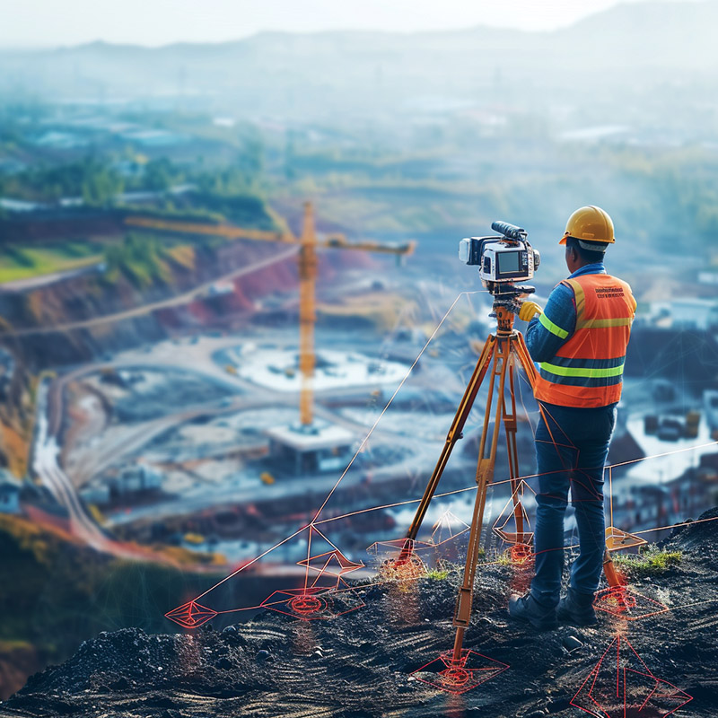
GNSS is strongest with open sky. Around high-rise buildings, under bridges, in dense trees, indoors, or close to reflective surfaces, a robotic total station, laser, scanner, or hybrid workflow may be more reliable. Good construction positioning is not about using one tool everywhere. It is about choosing the right tool for the tolerance and environment.
Machine Control
Machine control is where construction GPS becomes visible on the jobsite. Dozers, graders, excavators, compactors, scrapers, pavers, milling machines, and wheel loaders can use GNSS or total-station positioning to compare the machine's cutting edge, bucket, drum, or screed against a 3D model.
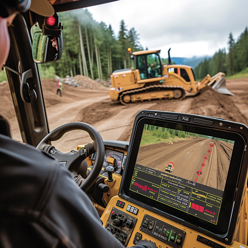
Systems range from indicate-only guidance, where the display tells the operator how far above or below grade the tool is, to automatic control that adjusts a blade or screed. The benefits can include fewer stakes, fewer grade checks, less rework, better material control, faster rough grading, and more consistent finished surfaces.
Digital Models And Field Data
Machine control is only as good as the model and control behind it. A 3D engineered model must represent the work clearly: surfaces, breaklines, alignments, offsets, utilities, subgrades, curb lines, drainage, and tolerances. If the model is wrong, the machine can build the wrong thing very efficiently.
Field crews also need a disciplined update path. Design revisions, RFIs, survey control changes, and as-built checks should flow through a managed process. Cloud-connected tools can help, but they do not replace model review, version control, and field verification.
Equipment Tracking And Utilization
GPS and telematics help contractors see where equipment is, whether it is working, idling, moving, or sitting unused. That matters because heavy equipment is expensive, frequently shared across jobs, and vulnerable to theft. Location data can support dispatch, rental decisions, maintenance planning, billing, fuel management, and recovery.
The useful metric is not simply location. It is utilization: which machine is actually producing, which is waiting, which is over-assigned, which needs service, and which should move to another site. Connected fleet data is strongest when it is tied to project cost codes, dispatch schedules, maintenance records, and operator workflows.
Drones, Mapping, And Progress Monitoring
Drones add a fast visual and measurement layer. Aerial imagery, photogrammetry, lidar, and ground control can produce orthomosaics, surface models, progress maps, stockpile volumes, haul-road views, and site documentation. These outputs help teams compare the built condition with the planned condition.

Drone data should be treated like survey data only when the workflow supports the required accuracy. Ground control, checkpoints, camera calibration, flight planning, processing settings, and vegetation or reflective surfaces all affect results. For payment quantities, utility locations, and high-tolerance work, verify the method before relying on the numbers.
Intelligent Compaction
Road and earthwork projects increasingly use intelligent compaction: rollers equipped with measurement systems, GNSS-based mapping, onboard displays, and reporting tools. Instead of relying only on spot tests after the fact, the roller can map coverage, passes, temperature, stiffness indicators, speed, and compaction effort across the work area.
That does not eliminate quality control. It changes the process. The contractor and inspector can see gaps, inconsistent passes, cold areas, or problem zones sooner. The result is better documentation and fewer surprises after the crew has moved on.
Safety And Geofencing
Location systems can improve safety when they are designed around real hazards. Geofences can warn when workers, vehicles, or equipment enter restricted zones. Proximity systems can reduce blind-spot risk. Site navigation can direct deliveries to the correct gate, haul road, laydown area, or crane pick location.

Safety alerts need careful tuning. Too many warnings create alarm fatigue. Too few warnings miss the point. The most useful systems combine location with site rules, equipment state, worker role, work zone status, and escalation paths.
Limits And Failure Modes
Construction positioning can fail quietly if the control is weak, the model is stale, the coordinate system is misunderstood, or the correction link is unreliable. Vertical errors are especially expensive because they affect drainage, pavement thickness, utilities, and quantities. Crews should check known control points, verify surfaces before production, and document calibration changes.
GNSS also has environmental limits. Multipath near steel, cranes, buildings, water, and bridge structures can degrade accuracy. Dense urban sites may need total stations. Indoor layout may need lasers, robotic instruments, QR-code workflows, or other local positioning methods. Marine work may require specialized hydrographic positioning and tide models.
Bridge Construction Example
The Hangzhou Bay Bridge case remains a useful example. Beginning in 2004, Trimble positioning technologies were used on the project, including RTK GPS systems, digital levels, and software. The challenge was not simply building a bridge; it was maintaining a reliable geodetic reference across a long transoceanic site with offshore work, barges, piles, prefabricated sections, hydrographic surveys, tides, typhoons, and difficult soil conditions.
On projects of that scale, conventional optical control alone can become inefficient as distances increase. Reference stations, RTK systems, onboard positioning, digital levels, and shared design data help keep survey, marine placement, topographic work, and construction activities aligned to a common reference. The lesson still applies: high-accuracy construction positioning is an integrated system, not a single receiver.
Implementation Checklist
- Start with tolerances: Define the accuracy needed for rough grading, finish grading, utilities, structures, paving, and inspection.
- Establish reliable control: Use qualified survey control, check it regularly, and document site calibrations and coordinate systems.
- Manage the model: Treat machine-control files as controlled construction documents with versioning and review.
- Train operators and surveyors together: Machine control changes field roles, so crews need shared procedures for checks, uploads, and exceptions.
- Plan connectivity: Correction services, radios, cellular coverage, cloud sync, and offline workflows all affect production.
- Verify before production: Check known points and test a small area before letting equipment build at scale.
Quick Recommendation
Use construction GPS as part of a controlled digital workflow. GNSS, RTK, machine control, drones, and telematics can reduce rework and improve productivity, but only when control, models, corrections, training, and quality checks are managed. The strongest contractors do not just buy receivers for machines. They connect survey, design, field production, inspection, and project controls into one disciplined positioning process.
References
Current context was checked against Trimble Siteworks Machine Guidance information, Trimble Siteworks documentation, Topcon 3D-MC platform information, Leica Geosystems machine control information, FHWA 3D engineered models guidance, and FHWA intelligent compaction information.