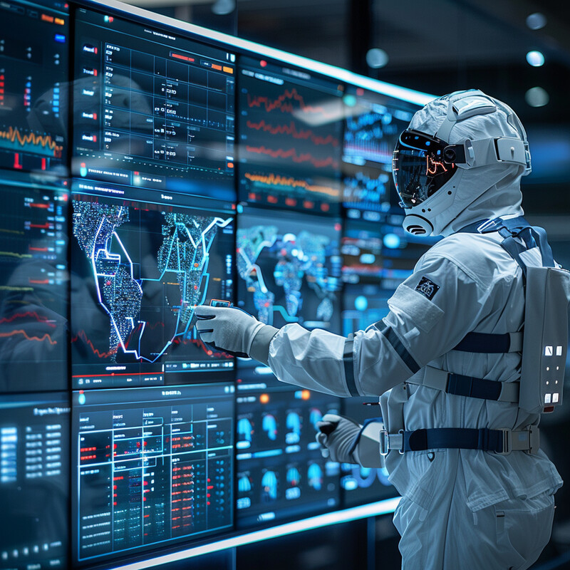
Disaster response gets stronger when it shortens the time between impact and action. That is where AI is proving most useful. The highest-value systems today are not autonomous robots taking over emergency management. They are tools that help agencies see damage faster, prioritize scarce resources more clearly, translate instructions more quickly, and update operational decisions as conditions change.
That matters because response failures are often information failures. Roads are blocked but not yet mapped. Damage is widespread but not yet ranked. Shelters are open but not matched to demand. Health signals emerge but are buried in noise. AI therefore becomes most useful where it supports earth observation, computer vision, path planning, machine translation, and operational decision-support systems.
This update reflects the field as of March 17, 2026 and leans toward official and primary sources from NASA, NOAA, NIST, WFP, WHO, DOE, and other operational actors. Inference: the biggest current AI gains in disaster response are in triage, coordination, and situational awareness, not in removing human judgment from emergency work.
1. Predictive Analytics for Early Warning
In disaster response, predictive analytics matters less as a futuristic prediction engine and more as a staging tool. AI helps agencies turn forecast, terrain, infrastructure, and exposure data into earlier decisions about evacuations, staffing, sheltering, and pre-positioning supplies. The strongest current gains come when predictive analytics supports response preparation before impact and rapid re-prioritization as conditions change.

NOAA added multiple AI weather models into DESI on January 28, 2026, bringing faster model guidance directly into forecaster workflows, while Google's Flood Hub is increasingly aimed at governments and aid organizations that need operational flood forecasts rather than public-facing maps alone. Inference: predictive AI is most useful for disaster response when it extends lead time for concrete staging decisions, not when it promises certainty about inherently uncertain hazards.
2. Damage Assessment
Post-impact response depends on compressing the time from imagery to usable map. AI-driven computer vision, change detection, and earth observation help responders identify destroyed buildings, flooded blocks, blocked roads, and disrupted infrastructure before field teams can inspect everything manually. That makes the first operational picture faster and more actionable.
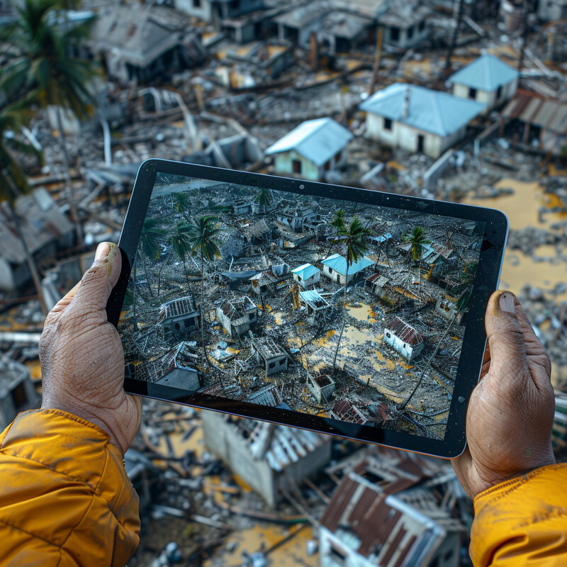
NASA's hurricane-response work shows how AI and open science can speed extraction of damage signals from imagery for post-storm analysis, and WFP's SKAI platform uses satellite imagery and machine learning to deliver near-real-time building damage assessment and situational awareness for humanitarian operations. Inference: AI damage assessment is strongest in the first 24 to 72 hours after impact, when responders need to know where to search, where access is broken, and where aid should go first.
3. Resource Optimization
Resource optimization is less about finding one perfect route and more about comparing tradeoffs under shortage. Which roads are still usable? Which warehouses still have stock? Which communities are cut off? Which transport assets should move first? AI helps by combining demand signals, access constraints, and path planning into operational recommendations for logistics teams working under uncertainty.
WFP's UN AI Smart Mission Planner is designed to reduce mission-planning time and improve the use of shared transport resources across emergency operations, while WFP's SCOUT tool shows how optimization AI can cut emergency supply-chain replanning from weeks to a day in volatile operating environments. Inference: resource-allocation AI is most credible when it helps human logisticians compare options faster under severe time pressure, not when it tries to automate humanitarian judgment end to end.
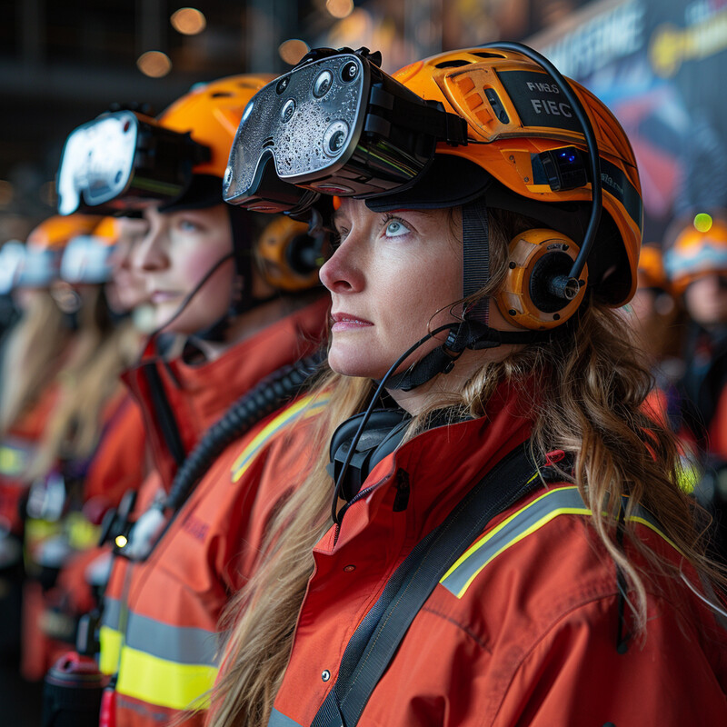
4. Search and Rescue Operations
AI-assisted search and rescue works best when it narrows the search field before responders enter dangerous terrain. Drones, robots, and handheld systems can combine imagery, thermal signatures, audio cleanup, and sensor fusion to flag where survivors may be trapped or stranded. The practical value is not fully autonomous rescue. It is safer and faster triage in unstable environments.

NIST's ResponseWing challenge highlights the direction of travel for search technology by focusing on fast 3D scene mapping, two-way communications, and measurement in GPS-denied emergency environments. Peer-reviewed work on GAN-based UAV noise suppression shows a more specific benefit: machine learning can reduce rotor noise enough to improve the chance of hearing distant human voices. Inference: AI search tools are strongest when they make hazardous scenes faster to scan and safer to enter, not when they claim to replace trained rescuers.
5. Communication Systems
Disaster communications are not just about keeping radios alive. They are also about getting accurate instructions to the right people quickly, in languages they understand, across channels that may be degraded or congested. AI helps most here through faster machine translation, message triage, and information-routing support layered onto resilient public-safety communications networks.

GAO reported on January 26, 2026 that the National Weather Service was using AI to translate some weather products into five languages, with about a quarter of forecast offices and the National Hurricane Center participating as of December 2025. At the network layer, FirstNet's always-on priority and preemption remain a core disaster-response capability when public networks become congested. Inference: communications AI matters most when it reduces language delay and keeps mission-critical traffic moving, not when agencies assume one alert channel is enough on its own.
6. Victim Identification
Victim identification is one of the most sensitive disaster-response uses of AI. Systems based on face identification or other biometrics can help reunite families and identify missing people faster, but only if they are used as supervised candidate-generation tools rather than unquestioned final arbiters. The strongest real-world value is often family reunification in chaotic mass-displacement settings.

After the February 6, 2023 earthquakes in Türkiye, TÜBİTAK's DerinGÖRÜ face-recognition system was adapted to help the Ministry of Family and Social Services identify unaccompanied children. TÜBİTAK later reported that more than 300 children had been matched through the system, while ministry reporting in early 2023 described the same tool as part of a wider reunification workflow. Inference: AI identity matching can materially speed reunification after disasters, but it should remain tightly governed with human verification, narrow purpose limits, and strict data-handling controls.
7. Simulation and Training
AI-supported simulation helps responders rehearse rare, high-consequence scenarios before they happen. Virtual environments, adaptive games, and scenario generators let teams practice triage, evacuation, infrastructure repair, and coordination repeatedly, with feedback loops that static tabletop exercises struggle to provide. The strongest value is repeatable decision practice under stress, not flashy visualization for its own sake.
George Mason's Go-Repair and Go-Rescue projects show how reinforcement-learning-driven scenarios can help trainees compare their choices against optimized alternatives in infrastructure and evacuation settings. A 2024 BMC Digital Health study on immersive mass-casualty training reported high realism and strong learner acceptance, which matters because willingness to train repeatedly is part of what makes simulation useful. Inference: AI training systems are strongest when they make difficult scenarios cheaper to repeat and easier to evaluate over time.
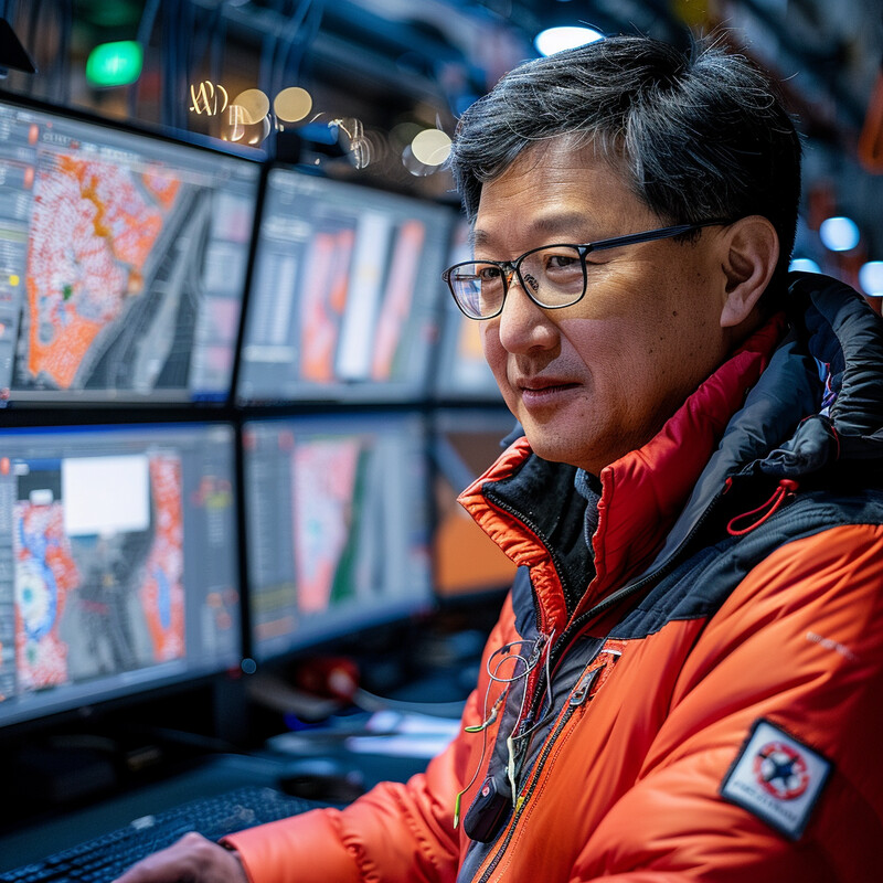
8. Real-time Decision Support
During an active incident, the limiting factor is often not data collection but cognitive overload. AI-backed decision-support systems help responders combine maps, weather, imagery, infrastructure status, and field reports into a more usable operating picture. The strongest systems narrow options and surface tradeoffs while leaving command decisions with humans.
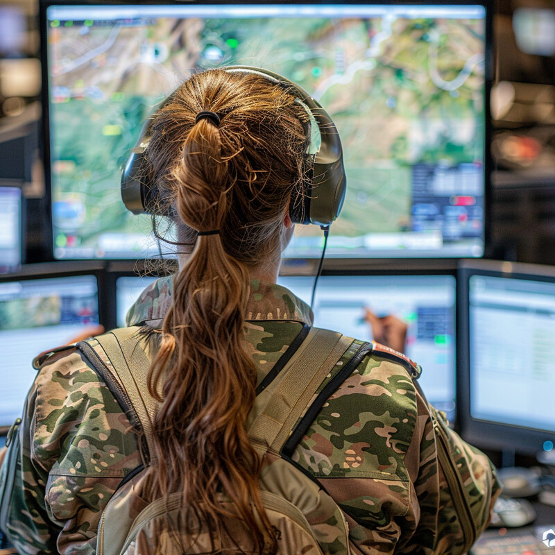
NIST's CommanDING Tech Challenge focused on information-rich interfaces that help incident commanders work across video, maps, sensors, and indoor tracking data under pressure. NASA's E-DECIDER tool offers another grounded example by providing fast environmental intelligence for hazards such as wildfires, smoke, and extreme heat. Inference: real-time decision support is strongest when AI reduces cognitive load and time-to-interpretation, not when it hides the basis for a recommendation behind a black box.
9. Infrastructure Recovery
Recovery is where response becomes a sequencing problem. Which feeder should be restored first? Which bridge needs inspection now? Which water or transportation assets are critical to reopening whole neighborhoods? AI helps by combining damage information, telemetry, and service dependencies into better restoration priorities. This increasingly overlaps with digital twins and AI-assisted restoration planning.

DOE's AI for Energy work explicitly includes storm restoration use cases such as damage assessment, outage forecasting, and optimal dispatcher location, showing how utilities are already applying AI inside recovery operations. NIST's recent resilience and digital-technology work points in the same direction by treating interoperability, preparedness, and recovery as connected system problems rather than isolated asset repairs. Inference: infrastructure-recovery AI is most valuable when it helps utilities and public works restore the most consequential services first, not simply the most visible damage.
10. Public Health Monitoring
Public health is a major second-order disaster-response problem. After floods, storms, displacement, and infrastructure failure, health agencies need faster signals about outbreaks, contamination, and unusual symptom patterns. AI helps by scanning large volumes of reports, open-source information, and field data for early warning signs of deterioration. In practice, this is mostly an anomaly detection and surveillance problem rather than an autonomous diagnostic system.
WHO's EIOS initiative now serves as a near-real-time, AI-supported open-source intelligence system used by governments and international organizations for public-health decision-making. WHO's EWARS is designed specifically for outbreak detection in emergency settings, including after natural disasters, and remains a practical tool for rapid field surveillance where infrastructure is weak. Inference: public-health AI is strongest as an early signal and coordination layer that triggers human investigation, not as a stand-alone replacement for epidemiology teams.
Sources and 2026 References
- NOAA GSL: New AI weather forecast models added to DESI
- Google: Advanced Flood Hub features for aid organizations and governments
- NASA Science: NASA AI, Open Science Advance Disaster Research and Recovery
- WFP Innovation: SKAI
- WFP Innovation: UN AI Smart Mission Planner
- WFP Innovation: SCOUT
- NIST PSCR: ResponseWing
- GAO: Weather Safety - Agencies Face Challenges Related to Multilingual Weather Alerts, and AI Project Needs Better Planning
- FirstNet: Priority and preemption
- TÜBİTAK MAM: TÜBİTAK Continues to Provide Active Support in the Fight Against Earthquakes
- Anadolu Agency: Turkish ministry launches search tool to reunite unaccompanied children with their families
- George Mason University: Transforming emergency response training through AI and interactive games
- NIST PSCR: CommanDING Tech Challenge
- NASA Applied Sciences: E-DECIDER
- DOE: Artificial Intelligence for Energy report
- NIST: Whole Community Preparedness in Smart Cities and Communities
- WHO: Epidemic Intelligence from Open Sources (EIOS)
- WHO: Early Warning, Alert and Response System (EWARS)
Related Yenra Articles
- Early Warning Systems for Natural Disasters covers the pre-impact forecasting and alerting layer that feeds response staging.
- Geospatial Analysis provides the imagery, mapping, and change-detection backbone behind many response systems.
- Water Quality Monitoring shows how environmental health surveillance fits into post-disaster operations.
- Climate Adaptation Strategies connects emergency response to longer-horizon resilience planning.
- Seismic Activity Prediction goes deeper on one hazard where seconds of earlier awareness can matter.