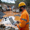
Remote Sensing and Aerial Surveillance 2 - Image Index | 10 Ways AI is Improving Water Quality Monitoring Remote Sensing and Aerial Surveillance in Action: The aerial surveillance photo captures an individual in an orange jumpsuit with reflective stripes and a yellow hard hat, standing on a rocky outcropping overlooking a body of water that may be a lake or river. The person is holding what appears to be a tablet in their left hand, possibly using it for remote sensing or surveying purposes. The surrounding landscape features rugged terrain, including rocks and scrubby vegetation, suggesting a remote area. The image conveys a sense of exploration and data collection in an outdoor setting. The green color dominant in the water suggests that the body of water is likely to be a lake or river. The orange jumpsuit worn by the person indicates that they are likely working on a project related to environmental monitoring or surveying. The yellow hard hat adds another layer of safety gear, indicating that the person may be working at heights or in hazardous conditions. Overall, the image suggests a remote sensing or aerial surveillance operation taking place in a rugged outdoor environment.